In the latest post, I forgot to add the link to the PSD files I was using for the Oerth continent map. You can download it here:
https://www.dropbox.com/s/6rn5cvpdnq12ahf/Oerth%20Continental%20Layout%20%20-%2043.psd?dl=0
The resolution is 2700 x 1350 and its 73MB in size so it should work well in GIMP as well on almost any machine.
It is has all the layers, masks and styles for both the elevation coloring, climate and Heightmaps, for those of you who wants to make their own version of Oerth!

I've been pestering you with my Oerth planetary modeling project for a while now, and thank you so much for all the support and interest!
Here comes what I see as the first complete version of my Oerth Planet model. This only means it is good enough to do the job needed, to be base for start of GIS based mapping. For being my very first planetary map I'm very pleased with how it turned out, it is rough but useful, inspiring and a good base for further refinement and detailing. You know me and my maps, a map can and should always be improved to stay relevant and useful. With the Oerth map its more than usually true!
The updates since my last post are a few adjustments in the southwestern parts of the Flanaess map area to match the existing map better and Climate and texture maps made.
Next up with the Oerth Planetary Project is to look at polar ice and ice ages, that is coming in a few weeks.
Work on a secret Greyhawk project have also started. Something different from what I'm normally do, that have been on my to do list for a long time, and thanks to your support I know have the time to start working on it. I will work on a sample that will be posted here for Patreon members only in a couple of weeks, and presented publicly on the next episode of the Fantasy Mapping Show. Then we will see how well it is received, if you guys like it and think it is a good idea it will be a part of my Greyhawk mapping going forward, if not then it will be one of many abandoned projects.
This Friday June 18th @8PM EDT, together with Alyssa Faden and Jay Scott we are starting a new Twitch Show dedicated to Fantasy Cartography. A two hour show once a month where we want to cover all sorts of topics related fantasy cartography, invite guests from cartographers, publishers and DM's to talk about various aspects of mapping. Jay is producing and giving us lots of good DM insights!
Alyssa Faden is a very accomplished professional fantasy cartographer with a bit of a different approach and produces gorgeous maps with a huge amount character, it will be a lot of fun to do this together with her.
The first show will be telling more about what kind of topics we want to cover, give a glimpse into our humble beginnings in cartography and generous amount of time for Q&A.
Thank you all for making it possible for me to take the time to set up and participate in things like this, we hope it will be an interesting show giving inspiration, insights and help in your mapping efforts and mapping use for gaming.
What topics do you want the show to cover?
aan asked me some great questions in a comment recently and I'm posting my response as a full blog post to be able to elaborate a bit more.
Preparation
Coastlines are one of the most defining features of cartography, and in many ways even more so when you work in 3D, so they need a lot of steps and input to look good in the end. In most cases there are already some form of map or description of the area that the final map need to adhere to, meaning follow more or less strict. How strict depends on how the existing map or text portray it compared to the result needed. If the goal is to create a realistic model of the terrain and what we have are a vague text or an illustration that looks cool but very unrealistic, a lot of changes needs to be made. In other cases the problem is the opposite, you might get a picture of a terrain for a commission and the goal is to use that as a base for something that should be part of an illustrative fantasy looking parchment map. In my work the former is the most common case, but both ends or cases in between occur all the time.
When I have decided the goal and gathered the sources, the next step is to prepare a useful guide image from the material. This usually means using Photoshop to get rid of things like text symbols and things that are clutter and in the way. The previous map might be done in some artistic perspective so stretching and warping it try try and create a top down view are needed. This process can range from very easy to very complex depending on the quality and size of the source.
If all I have are text I read it all and take geographical notes, and then sketch out a simple terrain and then read the text again to make sure that all the geographical mentions in the text matches my sketch. Then I use imagination to try and sketch out the rest of the terrain to fill out the gaps keeping in line with the theme and spirit of the story. The overall environment of the story is key for this, is the story set in a jungle, mountains, what is the climate, is it a demonic waste land, or a idyllic farmland and so on.
Using the sketch I can then use that as an overlay when working in World Machine or Gaea to create the terrain. I'm only using it for visual guidance, tweaking the fractals to generally follow the guide image coastlines. It is possible to create a mask (a black and white or greyscale image) in Photoshop and use that directly in terrain creation. This have a strong tendency to limit the fractals creating harsh unnatural, sterile coastlines, but in some cases especially with large scale maps it can work well. Vectors are possible to import and use in World Machine but they are tricky to get right and require even more work to get detailed.
Create
Yes, I use World Machine or Gaea to try and sculpt terrain to match the guide image. It sounds simple but can be a true pain, fractals live their own life and you need to terrain features like hills, rivers and erosion, terracing an more to also work together to create a good looking terrain that meats the specifications. The coastlines are only one of the parameters to get right, import yes, but only one of many things to make a good looking terrain.
The key is to try and understand how the different aspects of the process like the fractal generating the elevation, erosion, filters like Terracing, Glaciation, Displacement and Flow Restructuring, each affects the result so you can tweak the the right way. Then you have the different forms of Erosion that are often needed to make the terrain look realistic, like old weathered rough low hills for that haunted moor, or wind swept rocks for a sandy desert. Costal Erosion is especially critical for coastlines, forming long beaches of flattened terrain and shallow water aplenty, but that needs to be applied sparingly, far from all coastlines are pristine beaches.
Islands and, bays and inlets are features that I try to program into the cocktail of fractal generators, filters and erosion used to create the terrain. You use shapes in World Machine to apply the various effects and there is a setting that lets you apply a "warping factor" as well as a fall off helping you to create the endless varying of the same theme across large areas that we see all over the natural world. The key is to blend a lot of different factors together and let probability and randomness work out the details for you. It is a trial and error process, but over time you learn and you can re use combinations that worked well in the past.
The key is to study the real work, imagine what a fantasy world could look like and then use a systematic trial and error to try and achieve your vision.
Other ways of creating coastlines
The way I described it above is the way I go about creating coastlines for 3D terrain. That might not be what you need or want to create, which means you can use different approach using Photoshop, texture generators, or even pancakes!
What you need are some fractal large scale random pattern, that can come from almost anywhere, real world data, patterns in nature, random scribbles, or the burn marks on pancakes. Make pancakes in a frying pan, use your smart phone to take a top down image of each pancake. Use filters in Photoshop (or GIMP) to reduce the image down to pure black and white and you have a set of coastlines, islands or lakes as needed. Combine, resize and rotate and you can create any type of realistic set of coast lines for any type of project. Randomness, creativity and base knowledge of a image editor software is what is needed along with a vision of what the goal is for what you need to accomplish.
Lots of things besides pancakes can be used for this, clouds, splash patterns, a rock wall, bark on a tree etc. Let nature inspire you!
Taken my Oerth planetary project for another spin to try and improve it a bit more and take a first look at drainage basins and major rivers. Given the simple elevation maps some color tweaks to make it a bit easier to read, with a purple for depressions and black for deep depressions.
Focus for this round is the Empyrea homage in the Solnor that have been given some more shape and character but kept the same general size. I wanted to get away from the big blob to something more interesting, and hopefully this is better. Added an loose string of islands fanning out north along an extension of the shelf north towards Fireland.

Starting to get the feel that the major stuff are now good enough to go in and have a first look at the major rivers. Remember that the rivers shown are only major drainage channels home to the biggest rivers. Some of these rivers will only be seasonal or only flow during very wet conditions, for example the river flowing west across the Dry Steppes creating Lake Udrukankar. It probably only comes to life a few weeks late spring early summer when snow melt from the Crystalmists feeds it and the lake, disappearing quickly in the hot and dry conditions only to come back again next spring. During those short weeks it is the longest river with its roots in the Flanaess.

Oerth's longest river in this version of the planet are in the western Oerik originating in the central desert, with a similar story of seasonal snow melt from four mountain ranges giving it enough staying power to be flowing, at least to some degree, all year round. It will pick up more and more tributaries and water as it flows south ending up as a huge river with an estuary in the taiga on the Southern Oerik coast. Since it flows into colder regions it is likely to have huge overflows when spring flooding hits the still cold and frozen southern regions, like Canadian and Russian rivers flowing into the arctic. Makes for interesting adventuring geography!

Oerth comes with about half a dozen mighty tropical rivers in the class of the Amazon or the Congo. Again it is the Western Oerik that is the home to three of them, with the biggest draining the eastern part of the rainforest of the Western Oerik. It is on a similar or larger scale than the Amazon, forming a huge lake basin half way through its flow north. It drains not only millions of square miles of tropical rainforest, two large mountain ranges as well, so it will be navigable for a large part of its length for all types of ships. Its two neighboring rivers are smaller but still mighty, rivaling the the Velverdyva in length and probably carries more water, being in the class of the Mississippi, Nile or the Volga.

The most unusual river must be the river in the eastern side of Western Oerik flowing north in the huge basin east of the big canyon. It start in a desert valley far south with mainly seasonal melt water. After more than 1,000 miles north it hits the tropical region where it receives a major boost from the humid air from the east and the drainage from some of the mightiest mountains of Oerth both east and west of it. This makes it top up the old ocean remnant in the center of the valley. During high flows this lakes drains north into an even lower depression that far below sea level where its water forms a large dead sea like body of very salt water surrounded by huge salt flats. This water sits here until evaporated away by the hot desert sun.

The "banana" peninsula in the south central Oerik have been given a work over splitting up the general shape to make it stand out a bit less. The final thing to have been looked at this update is the Sea of Dust that now have the depressed areas marked.
With this iteration I'm starting to have a really positive feel about this planetary model being good enough to be really interesting, and useable as a diverse and robust platform for adventuring across a landscape that can harbor almost anything you like, and still have room left over to surprise!

Here is a version with the continents of Earth on top so you can compare and see the true size of Oerth's features: https://www.dropbox.com/s/km7fzd9wvg6lwkg/Oerth%20Continental%20Layout%20w%20Earth%20outlines%20-%2040-3.jpg?dl=0
Try it out in https://www.maptoglobe.com/
I've got multiple requests to do political maps of the Flanaess for both 576CY and 598CY, so here is a set!
First a HUGE thank you, over 300 Patreon members, wow, thank you all for your support!!!!
And thank you all for all the great feedback on my Oerth modeling, lots of good creative points that I have tried my best to address with this update. I've recruited help of friends and friends of friends who are experts at climate, oceanography, ecology and geography. Over a series of zoom calls they have helped me trying to come up with cool solutions to try and improve on the Oerth model. There were three main issues with my first version, too much desert in the west, more islands would be better and the "cowhide factor" is still too high.
Below is the revised continental layout:

My goal is to try and improve on the three mentioned issues and still try to honor the DA1 map and the other scare source material available. Lets start in the North Western Oerik where I hade made into Hot Steppes and Desert, and the Sundered Empire Map made into a enormous forested and fertile region. So how to turn desert into a lush forest? You have to give the region a decent amount of rainfall reliably spread out over the year. In order to increase the rainfall in the desert zone we need to bring in humid air and keep dry air away. We started by adding a group of islands in the ocean north of the NW tip of Oerik, large enough and placed to divert the ocean currents coming across the Solnor from the west south along the northern Oerik and then sweep north effectively revering the gyre from my previous version. This will bring in warm moist air from the west rather than cold dry air from the north giving us a good start with a forested peninsula sticking out.

Next is to bring the ocean south by creating a large inlet just west of the peninsula. To make it more interesting I broke it into two with a land tongue and sprinkled in some islands. We added mountains east and west of and they are especially high in the east to create a barrier from the prevailing eastern winds brining in dry desert air, instead forcing moist ocean air south. The humid tropical area at the equator has lots of humidity, so instead of if having most of that flowing west to the coast we added a low range of hills to force the a large part of the rainforests to drain NE. This will fill out the depression SE of the added ocean inlet making the climate humid subtropical to tropical as well as make the geography much more interesting. Hills and mountains in this area will be mostly covered in vegetation ranging from tropical to temperate depending on elevation and direction. The added islands will have a climate similar to Ireland with an oceanic climate.

Here is the legend with adjusted matching colors.

Western Oerik is in this version given a much larger area of Tropical Rainforest and Savannah in the northern half, and a much more broke up coast in the southern half along with an rearrangement of the mountain ranges to again keep the dry desert air away from the coast, will make for much larger Mediterranean and Humid Subtropical areas. The broken up coast and added islands makes the geography more interesting, reduces the cowhide factor and also better matches the Sundered Empire map.
Next up is the central valley of Western Oerik, east of the big rift. In my firs model this was hot dry depression shielded from the rainforest east of the huge mountain range. By creating a series of canyons that opens up for winds from the east this depression will become a huge tropical rainforest oasis in a very hot dry desert and rivers draining the mountains will create a lake that seasonally grows to the size of the Nyr Dyv . East of the lake will be a hot steppe before some of the most impressive mountain pillars on Oerth with large valleys covered in forests of all kinds, a very diverse mix of biomes and adventuring possibilities. It is important to know that climate zones are not monolithic, just because an area is a desert doesn't mean that there are only sand and rock. If you take the Sahara or the Deserts of South Western USA there are large areas with varying forms of vegetation including forests where there are water, open or in aquafers.
Thank you so much for your help, I think this is an large improvement and we are getting closer to a really useable model of Oerth.
This post is a month late, sorry for hinting at things and that information is coming and then keeping things to myself. The main reason for this are that my mother got a cancer diagnosis a month ago and even though I live 5000 miles away from here there was still a lot of things to take care of, just in case of the worst. The prognosis looks much better that what we feared initially, and she is undergoing surgery tomorrow. My calendar for this fall have also been in limbo for a couple of weeks and I've just now confirmed that there will be way more time for me to work on Greyhawk maps this summer and fall, there are some advantages with a pandemic! I'll tell you more of what has been postponed to next year soon when it it official, in the meantime lets dive into what is going on right now and what I'm working on!
The Fantasy Mapping Show
Alyssa Faden and me have decided that we need to talk about maps more, so with the help of Jay Scott aka. Lord Gosumba we are starting a new Twitch Show "The Fantasy Mapping Show" which will be a monthly two hour show about all aspects of Fantasy Cartography, from the Underdark to Space, from rooms to worlds and from painting to programming. We want to hear from you to know what topics you want us to cover! First episode will be Friday June 18th @7pm EST on https://www.twitch.tv/lordgosumba
Oerth
Thank you again for the wonderful reception of my first Oerth planet model, this have given me a taste for more! I'm looking into variants like ice-age and historic (geologic time) versions to drill deeper into the topic. Dissecting Oerth is another interesting project related to this. My own campaign ideas are that the planet actually hosts the inner planes, there of comes the name. The elemental planes are actually a dimension of the planet itself, and elemental interaction creates both underdark realms, a fantasy version of plate tectonics and can be a driver of climate. This way things can be adjusted a bit as needed. A more conventional planet model need to be looked into as well.
Campaign Maps
My Shield Lands campaign are up and running after a bit of struggling start. The party is still in Auldet in Shield lands and are fighting hard to retake the keep from the Iuz priests who are now countering with laying siege to the village with the animated corpses of all the inhabitants they have killed during their 15 year occupation. The maps of the area are coming together and live up to my expectations, there will be much more coming this summer in the form of Shields Lands map coverage as a first test of my new mapping standard.
Lendore Isles
This project have been in the launching phase for two years now, I haven't had the workflow or tools ready to give Lens Islands justice until now that is. I will map Lendore Isle and its smaller sister islands in 5ft/px detail just like my Shield Lands Campaign maps. Detailed enough to see individual houses, roads and trees.
Patreon
For a year my Patreon have operated under "pandemic conditions", having all post public as a way for those who could afford to spend money on very much non-essential things like fantasy maps. Thanks to so many of of you have continued to support me I've been able to keep up my Greyhawk related work the past year, thank you so much everyone!!
Now it is time to both go back to normal and shake things up a bit, start looking forward and make plans for the future. I have had my goals and tiers the same for the past three years, and to be honest my Patreon Goals was more than a bit fussy and something I just filled out to get things going. Support for my Greyhawk mapping endeavour is now solid at around $900/month which means I can schedule a large chunk of time every week to work on my Greyhawk projects. So what can be done with more resources, what do I want to do with more money?
My computers are four and five years old, still functioning but getting a bit out of date and lacks performance. Anyone who have tried to buy powerful computers have noticed that it has been hard to find certain parts and prices have been and still are absurdly high. So computer investments have to be postponed for a while, maybe next year will be more sane when it comes to computer hardware.
GIS
The next big leap in my map making will be to start using GIS (Geographical Information systems) tools and standards. I've been prepping myself knowledge wise for this one for several years, and soon ready to launch a new GIS based edition of my Greyhawk maps. My Oerth modeling is a step in this, figuring out the placement of the Flanaess. When we reach $1000/month will be the official go ahead for this. It is initially very time consuming referencing and then placing everything on the current map properly on the planet, but worth it for the flexibility and usability of the date once defined. Maps with different styles, sizes and publishing methods will be much easier to create, for example online versions of the map.
My plan with GIS is to create a repository for Greyhawk geo data that can be downloaded and used in QGIS and other cartography tools the same way you would use real world data. QGIS is an open source tool so the cost are none, but you still need a bit of knowledge to create your own versions of the map which is unfortunately true regardless of how you try and do it. The GIS Goal is also an important step leading up to my next goal.
If we can reach $1500/month it is time for something I'm getting asked all the time, prints! With GIS making it much easier to create a variety of map versions specially made for print, and the resources for me to do test prints to make sure they look right. The test prints will then be raffled out among Patreon members and used at conventions as promotion. It would be a dream come true to have the money to do cool prints, so far I've only printed my Flanaess map in full once, on over 60 sheets of 11x17 inch photo papers, which took days and cost more than I dare to think of on my ink jet, using up more than a dozed cartridges. Low cost generic ones, but still over $100, print is expensive. To help out with this I'm in talks with Noble Dwarf , who does prints and apparel and is located not too far from me. They have done some great work for other cartographers so I'm sure we can get something going when we have the resources. Will make prints easier to order and less costly, but we need to have a series of different maps of different sizes for this!
Unreal
The highest goal I'm going to list here now is $2000/month, and if we can reach that its time to level up into the world of Game Engines. The workflow I'm developing now is with the intent for the data to be used in a Game Engine like Unreal or Unity. This requires major investment in both time, software and knowledge. I've been looking at this field for several years and I think it is a major tool in the future for visualising, but also to make customization a lot easier. This is a full time commitment but with this technology it is possible take Fantasy mapping truly to the next level. I've seen a lot of promising projects in the small scale, but nothing on a world level which is where I want to start. Some VTT's and Campaign managers have robust API's which makes interaction possible, and having an interactive world atlas in a new form!
Patreon Tiers
The three current tiers have some glaring issues, the main one is the $3 tier has been sadly neglected and underused. Haven't been able to create a lot of my own campaign content, and most of it should go directly to all of you and then to the whole Greyhawk community as my other content. The other tier problem is that the $1 tier is plagued by the fact that a disproportional amount of the money get lost in fees.
To try and fix this and also make sure that my Patreon is still accessible without a huge investment each month I suggest an updated tier structure:
$2 Adventurer Tier
All the stuff from the $3 tier for a bit of less money. Giving you early access to all my maps right away including Discord. What happens to the ones who are $1 tier? You will be grandfathered into the new $2 tier and stay on it for $1 as long as you keep your membership active.
$5 Cartographer Tier
Will continue to be the "technical" tier giving you "How To" and other articles, source material and similar stuff. Some of that will be available for everyone later and some will be for the tier members only.
$10 "Vanity" Tier
I sometimes get asked, how do go about pledging more? I'm so humbled by this and haven't really known what to do, what to give and such. Of course I want to make it possible for those of you who want to support me more. This Tier will get you a special mention on maps, on my website and promotional material. This can be your name, logo or some other message. For legal purposes I have to state the following: I retain the right to not publish names or images I find inappropriate for any reason.
Special blog posts where I discuss project ideas and things to come before posting them to the other tiers are another treat I can offer, but to be blunt this is a tier primarily for those of you who want to be my biggest supporters.
The New tiers and their Annual plans will start July 1st.
Flanaess Map and Atlas 2021 Edition
I have a whole Evernote notebook full of map updates and I keep working on the new edition a few hours a week editing and doing research. The Atlas Edition will be expanded south to include the Ilse of Dread and other islands in the Vohun Ocean. Work on the terrain have already started, and my goal is to have the new editions ready this fall. I haven't decided the format for the Atlas yet. Last years remake with a "double"11x17 inch format was cool, but a lot of extra work and also had the drawback of being put together in Photoshop, which meant loosing the vector quality of text and symbols. I have to make some nest of better ways to do it that are both effective, useful and keep the vector quality.
Thank you so much for making this possible!! 🙂
Time to put all the data from the previous steps to create an first true attempt at a planet visualization of Oerth. First I need to remind you that this is a only a first take on this and very much a work in progress, but it looked so damn cool that I could wait any longer and have to show what I'm working on.
I've used the elevation and climate model to create a rough sketch of what the planet actually looks like in summer, and it is summer in both hemispheres which is not natural but practical for this purpose. The ocean depths are only rudimentary done in Photoshop and need a lot of more work, as well as the the mountain colors, too many black ones. Despite all these shortcomings, I think is a stunning image!
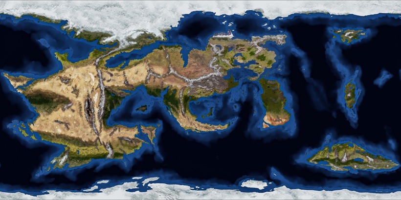
This equirectangular map can serve well as a start of making a more detailed image of the planet, both its landmasses and the oceans.
Thank you so much for all the support that makes it possible for me to spend serious amount of time on this project!!!! 🙂
A revamp of my Patreon will be announced soon, I'm working out the details, with new more defined and ambitious goals and a slight adjustment of the tiers.
First a heartfelt thank you, for all the wonderful and encouraging feedback you have given me for the first Oerth Continent post!!
This second instalment will be a look at the climate of Oerth and the Flanaess using a slightly simplified version of the Köppen Climate Classification. For this part of the project I've had help from a friend of mine who has working with oceanography and she has helped me explain how the oceans of the Earth works and what could be the case for a planet like Oerth. I've also leaned on my weather knowledge from having been a pilot and especially my long distance glider piloting which relies heavily on understanding weather patterns. Wikipedia and Artifexian's YouTube channel have been very helpful is applying this knowledge onto a fantasy world. I'm not an expert on climate matters, but I think I have enough understanding of the topic and knowledge of the Greyhawk setting to feel qualified to create a model of the planet that can be both useful and inspiring for Greyhawk fans who want to expand their campaign horizons.
A key guiding principle for this project is to try and create a planetary model that can work as a canvas for both the published stories we know and love, and an inspiration and help in creating new stories from other parts of the planet Oerth.
Below is an image showing what the climate looks like for Earth.

and here is Oerth for comparison (using a slightly simplified set of classes)

Several differences are striking, Oerth has way more deserts of both the hot and cold variety. This is due to mainly the larger single continent and a larger axial tilt. Larger continents tend to heat up away from oceans and the increased axial tilt exaggerates the tropics and poles, and on Oerth the Tropical Circles are at 30 deg N and S instead of the 23 degrees on Earth. The same goes for tropical rainforests and should have been the case for savannahs, but due to the dryer larger continent, ocean currents and mountains the savannahs are not as widespread as the could have been.
Here is the classes and the temperature and precipitation characteristics

Before we go into the details a brief discussion on climate science and how I have used it in my Oerth model. Climate are influenced by a myriad of things but since this is a fantasy world we can simplify things to aspects that can be more useful for our games. I've chosen geography, meaning where on the planet a region is located, ocean currents and general wind patterns.
Geographic location drill down to three general climate regions, the tropics between 30 deg N to 30 deg S, temperate between 30-60 deg N and S respectively, and the polar regions 60-90 deg N and S respectively as illustrated below.

The actual climate varies with airflow, ocean currents, humidity, and in some cases magic or other fantasy factors climatologists in the real world don't have to deal with. I've tried to keep them to a minimum and there are only one clear case of this and that is the Bright Desert, and even there it is only marginal as we will se when we get there on this journey.
Next up is to take a look at the global ocean currents and how it distributes heat and cold around the planet. Overall Oerth have a 57.56% land and 40.98% ocean (including major lakes and inland seas). Oerth's larger land area is all due to the landmass covering the north pole, apart from this difference the water land ratio are similar.

Due to planet rotation and size ocean currents form large rotating gyres, and on an earth-like planet (size and rotation) it will for two gyres N and S of the equator respectively. The can be likened to gigantic cogwheels that move the water around in the large oceans, where they form and how large they are are due continental layout. If we look at the Solnor Ocean north of the equator we have a clockwise gyre that carries warm water and humid water up along the eastern coast of the Flanaess making it both warmer and wetter way far north than would otherwise been the case.
Temperatures of ocean currents are relative, meaning they bring in water that are warmer or colder in relation to the average temperature of the area. So cold currents in the tropics can be way warmer than warm currents in the arctics. Warm currents generally makes areas more humid as well as warmer. Reversely cold currents, makes an area dryer as well as cooler. Cold currents in the tropics can mean desert or savannahs instead of rainforests. Warm currents in the arctic can mean oceanic climate instead of sub arctic boreal climate or even polar tundra.
How much difference currents make also depends a lot of the wind patterns, are they warm or cold on-shore or off-shore winds. Warm winds are generally a bit more humid than cold, and on-shore winds much more humid that off-shore winds. The combination of all this plus elevation, latitude and water presence determines the climate.

Winds are affected by planet rotation and temperature, and form bands of similar airflow across different latitudes. This is very obvious on giant planets like Jupiter and Saturn, but the same mechanics apply to smaller planets as well. The bands of winds mixes heat and cold across the planet, bringing warm from the tropics into temperate areas, and cold from the arctic south into temperate areas. These wind patterns are persistent enough to create typical weathers in different latitudes. Low pressure and humid along the equator. High pressure, dry areas north and south if of this create deserts on the edges of the tropics. The temperate zones are dominated by low pressure, humid and windy conditions, and the arctic see mostly high pressure cold and dry conditions.
I've done my best to try and take all this into account creating this climate model of Oerth. It gives a rich and varied planet to explore with lots of contrast and every climate zone we have on earth is present in significant areas on several locations.

The Flanaess has a rich climate diversity, from frozen arctic in the Black Ice, Yatils, Crystalmists and Corusk Mounatins. A band of boreal subartic from the Barbarian lands in the west to the Thillonrian in the east. Cold steppes stretches from west of the Fler river to the northern shores of the Nyr Dyv, and are again forming a large part of the North Province. A temperate humid continental climate reigns over lands from the Baklunish coasts in the west though Ket and much of the central western Flanaess. East of the grat lakes and the steppes are yet another large stretch of humid continental temperate climate. Each of the coastal areas of this temperate belt have wet humid conditions giving rise to rainforest on the north western slopes of the Yatils in Ekbir and showers the islands and cost of the Solnor with rain and warm winters. This is an effect not from magic but warm currents from the south and humid warm winds. It is only a local phenomenon in Ekbir but the much warmer currents on the Solnor warms up and humidifies and much larger area from Hepmonaland to the Sea Barons.
The lands around the Azure range from humid subtropic in the west and south to Mediterranean in the north and east giving it excellent living conditions, among the best of the planet in fact, so now wonder that it it has a large population and developed countries. Mediterranean, subtropics and warmer part of the temperate areas are the most prosperous climates to live in for humans and similar creatures dependent on agriculture. The Sheldomar Valley and Flamni basin are prime examples of good areas for empires to develop in.
Most of the Baklunish west are dry steppes that get progressively hotter and dryer the further south you get, which give much less support for civilisation to grow. There is a bad along the cost of the Dramidj and the western slopes of the Yatils all the way to Ket that the Baklunish have been taken advantage of and make a good living in. The far western end of the Dramidj is another example of good climate conditions for humans (and similar creatures) to thrive, giving DM's plenty of lands to develop civilisations in.
Apart from the Flanaess and the western Dramidj I see four main areas for bred baskets, the north western Oerik hava long coast and a peninsula with excellent conditions for settled life. The south western Oerik have a long subtropic coast and temperate lands next to it with a wet oceanic part in the south, like the Baklunish coast in reverse. The south eastern cost of Western Oerik is also a great place to settle with a drier Mediterranean coast and temperate interior. The northern end ready for your Eryptian civilization, with deserts as well as a fertile coast and south. The large southern continent gives Oerth a huge expanse of land in the temperate zone with great potential for agriculture, plus a cold wild southern interior and coast.
Western Oerik gives Oerth several deserts, a huge expanse of tropical savannah, some of its tallest mountains ranges and the biggest canyon on the planet. The mountains and inland seas gives it a wide range of climates in a close proximity, from glaciers, tundra, boreal forest to hot deserts in only a few days journey. Like a big version of California, Central Asia and Africa all in one.
There are lots more to look at when it comes to Oerth and climate, this is just a first look and I'm intrigued by all the possibilities!