Here comes another post about my House Rules project, this time its a look at the d20 resolution mechanics and a characters default features. I base them on D&D5E and Level Up Advanced 5E from EN Publishing.
This post is just a first look at the very basics. There will be follow ups on all of the things covered here in more depth. I'm very new to making rules and writing them, so please bare with me as I gain experience and learn.
You can get the PDF here: https://annabmeyer.com/Downloads/rules/Core%20Rules%20First%20Look.pdf
My plans are to have a reference website with all my rules, that both my players and anyone else who want to se them can access them, as well as in PDF and markdown versions. When they are more complete and have gone through more playtesting I'm planning to have them professionally edited, but for now things are in the development phase.
Development have is jumping a bit back and forth between tings, it follows me taking on different aspects of the game I want to tweak. After a deep dive into a specific area I often come back to how to integrate into the rest of the rules. In this case it is a look at the d20 resolution and its modifiers and how a character gains these and a few of its others default features.
This morning I've been writing down ideas around how to tackle dying, resurrection, undeath and what happens to a character after its dead. I have some ideas around that that I'm now trying to put into game mechanics and making them work with my magic rules, senses and my model for fantasy physics. All this while still trying to keep it simple enough to be playable and even fun. My approach is to keep most of the dice rolling and number crunching on the players side, and the need to understand how the world works and how to resolve things more on my (the GM's) side.

My GIS project is progressing and it is time to start preparing for the presentation side of things. Greyhawk suffers from some of the same problems as our reals world, it is is planet. With that comes the impossible task of convert a spherical surface onto a flat one. Its a problem as old as cartography and numerous ways of solving this conundrum have been devised over centuries of map making. The term projection is used on the various forms of bending a planet onto a map.
Real world maps are used for things like find our way across an ocean using compass, sextant and a map. This makes certain projections preferable to keep navigational calculations consistent and simple (read: add as little to the workload as possible). For our needs as gamers understanding what the world looks like is the key feature. To help with that we need to look at what kind of map projections will do the job best.
Lets start with a look at the whole planet of Oerth. Here seen in an Equirectangular projection

This projection is the go to for creating planetary maps, it has a 2:1 aspect which makes it easy to set up in Photoshop or Illustrator to work on continental layouts. The main problem with this very simple projection is that its only accurate at the equator, and gets progressively worse the father away from the equator you get. Below is the same image in an orthographic projection, meaning it a map "as seen from space", in this case centered on Greyhawk.

Orthographic projections are accurate at the center and gets progressively worse the further away from it you go. It preserves shapes and their relations to each other well which gives a good understanding of how the geography are laid out. Ortho projections are lousy for navigation but great for understanding and visualization. Ortho maps have a major limitation and that is they can't really show the whole planet, only the side facing the center point. So for whole Oerth maps we need to look at other projections.
Most world map of Earth use a Mercator based projection which is makes a planet fit in a neat rectangle easy to print or place on a book page. Here is what Oerth look like using this type of projection.

The benefits with this type of projections are that they preserve angles locally, meaning directions like north are the same across the map. To make this possible the shape and area or the land is distorted, which you can live with when you need the map to plot your route, but gives you the wrong information about distances and local terrain relations.
To present a whole planet for gaming purposes an equal-area projection is, in my opinion, my better for this. Thankfully there are a lot of the to choose from. The shape and area of the land is much better preserved, but the latitude and longitude lines are distorted instead. My favorite among these projections are Mollweide, its large oval is beautiful and it keeps a lot of the spherical feel, shows the whole planet and gives a good understanding on the geographic layout of the world.

Eckert is another projection of this type that comes in many variants, Eckert III is in my opinion the best. Below is Oerth using Eckert III.

Natural Earth is a slightly more compact version of Eckert which might be better for certain applications.

A number of attempts to give up on the idea of preserving any property perfectly and make a compromise that simply make things "look right", which have given us the "compromise projections". Winkle Triple is one of them.

Wagner IV is another one.

They are, in my opinion, like the equal-area projections but a bit worse since they try to be a bit more "navigation friendly" which makes land a bit more distorted. This also makes them lass useful for understanding what the world looks like.
When we move in regionally and look at our corner of the world, the Flanaess and its surroundings projections change a bit. The projection of the Darlene map is unknown, or non-existent, so a bit of guesswork is needed to place the Flanaess. Luckily we have several references which gives un latitudes and in a few cases even longitudes which I've tried my best to preserve.
Below is the Flanaess seen using WGS 84 which is an Mercator based projection that is industry standard. This map is close to the Darlene map is the way we are used to see our Greyhawk. In reality the northern part is exaggerated and the land distorted.

Lets look at the Flanaess using an ortho projection centered on Greyhawk, which lies conveniently in the center. This map is great to understand how things are related to the City of Greyhawk, and the center part of free from distortion.

Lets move in a bit and look at the regions of the Flanaess referenced in Adventure Begins and the Living Greyhawk Gazetteer using the ortho projection. For regional maps like this, the ortho projection works well providing a minimal distortion in the kay area and keeps the land shape and layout right. Below is the Bitter North using an ortho projection centered on the western Wolf Nomads.

Northern Reaches centered on the eastern Cold Marches

Old Aerdy West centered on Rel Mord

Old Aerdy East centered on Rauxes
 and a more zoomed out map centered on Rauxes.

Old Ferrond centered on western Furyondy.

The Sheldomar Valley

And finally the Thillonrian Peninsula

For regional and local maps ortho projection works really well, offering low distortion and high shape accuracy. Ortho maps works well by themselves. If you instead want to have the Flanaess printed on a number of small maps that can be laid side by side and match ortho doesn't work, and a Mercator projection like WGS84 works much better. The price you pay are increased distortion the farther north you go.
The projections used for real world maps are developed for viewing a 3D sphere onto a 2D surface. When you have a world and the purpose of maps are to show the geographic data you have gathered. For a fantasy world the situation is different, for starters the world doesn't exists in the sense that it can be surveyed using normal means. This means the data of the world needs to be created and then presented using cartographic standards.
Terrain tools (at least so far) works on a 2D plane which means having the 2D - 3D problem in reverse when creating terrain with the intention of making it fit a planet. Then converting it back into a 2D map again. Real world surveying is a challenging and expensive undertaking, but fantasy surveying comes with its own set och challenges as well. Information gathering from texts and fragmented maps, inadequate tools and having to work in reverse makes it both interesting and hard.
GIS is needed to develop maps that can be both printed and used digitally and work well for both uses. This means the need for both WGS84, ortho and a few other projections as well, I know I want that Oerth large poster map using the Mollweide projection!
To be able to instantly travel to another location is a staple in fantasy and the Teleport spell and other similar spells have been a staple in every edition of D&D. It has (like so many other things) being treated mainly from a game-mechanical perspective with a bit of mishaps and errors added. What if we instead looked at teleport (and similar spells) from a setting perspective, how do they work, wat limitations, dangers and quirks could we add and derive when it comes to the ways and means of magical transportation. The spells of interest usually falls under the Conjuration School, which doesn't gives us a good list of which spells that will most likely be affected by the ideas to come.
There are real world ideas for teleportation using what we know of quantum entanglement and other way out there schemes. For our purposes we only need to make it cool, reasonably easy to use and first and foremost make it fit a magical setting. I'm going to propose that there are more than one way to accomplish this, each with its own set of advantages and disadvantages.
Astral
Making use of the Astral Plane makes it possible to escape the limitations of the primal world, either in mind only which is fairly easy, or bring your body as well which requires much more of an effort (Teleport is a 7th level spell after all). The advantages are that you can reach a large part of the multiverse using this method and are not limited to places you can see or know well.
The drawbacks are that you need to either know the destination well, or have some magical means of targeting it (more on this later). Your travel can be detected and interfered with by those in the planes you need to traverse in order to get to your destination.
Ethereal
Travel using the Ethereal and ignore things like terrain and even the planet itself. It easier to master and also harder to detect at a distance for anyone not in the Ethereal Plane using magical means.
Less powerful than the Astral method, you can only reach across the prime (using the border Ethereal) or deep into the Ethereal itself. Another drawback are that traces of your journey can linger for quite sometime and can be seen and traced by those that can visit and properly sense the Ethereal.
Fey
The Feywild offers interesting and in ways powerful forms of transportation, like Tree Stride for example. It is very hard to detect and fairly easy to master, but comes with its own set of limitations. The main one is that it requires things that are somewhat connected to the Feywild, which are usually living in nature, and it requires their cooperation or at least acceptance for it to work, and it requires the creatures in both ends to be in on it. Creatures usually store memories, and can have motives and allegiances, sometime they can shift which can open up for interesting problems.
Shadow
Using the Shadowdark (Plane of Shadow) for your quick travel needs can be very convenient, shadows are found in lots of places, (usually) just a medium without an agenda. Hard to trace and even harder to detect from a distance, it is a very stealthy means of transport. It comes with risks, shadows are by their very nature fickle and can disappear as quickly as they appear. They are almost limited in what parts of the multiverse they are strong enough to be used as a mode of transport.
Elemental
Using the elemental planes to travel can be an tempting alternative to going there by normal means. Large bodies of a single element often have openings to its elemental plane, and portals to the elements can be opened using magic. A key advantage of using elemental travel is that it is very stealthy, away from the prime, astral and outer planes where most of able observers reside. Most of the elements are murky or solid (except air) which means senses are usually very limited in range.
A major problem with elemental travel is the very nature of the elements, they can be harmful, restrict breathing as so forth. Another major problem is the elements still adhere to the laws of the prime meaning travel speeds are as fast as they are on the prime. Elemental travel might be the sneakiest way around but it takes time, can be very risky and doesn't take you to large parts of the multiverse.
To know where you want to go and how to get there can be way more difficult depending on the nature of your destination, and its surroundings. The locations in the prime are easy to get to if you can see them or are intimately familiar with them. Intimately familiar means you have been there for a length of time, and crucially, you know how it relates to the place you are going from. So for a teleport to function well you need to both know where you are, and how you got here from your destination. This can be tricky if you have used magical means to get to where you are or demi planes and other forms of plans disturbances are at play.
Gates and Portals
Gates and portals are a way to overcome some of the problems reaching your destination by creating a place that have way to aid magic travels, in some cases just provide a higher degree of certainty for those who cast a teleport spell and other a permanent connection open for all to use for travel.
Gates and Portals can be very complex and require keys, special triggers like spells or only work at special times or conditions. Some of them are set to a specific destination, others can shift due to circumstances.
Forks
Planar Forks are a kind of "teleporting" key that can be set to guide you to a certain place. They are magical in nature and requires the creator to either have been to the location in question or its true name (which can be for a place as well as a creature). True names are very hard to find and understand which makes Forks very valuable and hard to create and come by.
They are magical meaning they can be detected, and they don't make the use of teleportation more stealthy.
Beacons
Like a Fork but it works at the destination and sends out its magic to guide teleporters to help them steer right. They have a range and work in a medium of some sort, like audio, smell or light in the prime. Beacons can also be way more special, working in the Ethereal, Astral, Shadow or Fey, sending pure magic, good or evil for miles around, sometime even across whole planes. This is up the the DM to create some flavorful beacons, like the Eye of Mordor for example, that has more than a single purpose.
The general rule is that the more useful a beacon is the more conspicuous it is. Beacons can be detected as far away as they are useful as a guide, often even farther away.
What happens when you miss your destination, something or someone messes with you on the way, or the destination itself is not stable enough to be there when you arrive.
Missed Destination
Magic travel is almost always inherently risky, and you might not end up where you intended with mild to catastrophic consequences. How likely this is depends on several factors like knowledge of destination and how to get there, the way you travel, magic or other forms of interference. Some forms of magic travel are riskier than others like shadow that are very shifting by nature. The current Teleport spell provides a good base table for missed destination.
Detection
The chance, or rather risk of, being detected while magically traveling doesn't have to mean anything, but it can be ruinous depending on the destination and/or purpose of the journey. The chance, range, means of detection and information obtained depends of where you travel and hoe the detection is attempted.
Here you can be both logical and a bit fantastic. Determine what kind of senses works where and then add in a bit of uncertainty, like protection spells that hides your identity but not prescence for example.
Detection can work both ways, the traveler might be able to detect attempts to actively scry for example.
Interference and Interception
This is a both the most interesting part of this discussion, but also the one that can ruin the fun of using magic transport in your game. It needs to be applied with reason and logic (fantasy logic that is). Magic forms of chase rules might work in some instances. Make sure that interception is a process that requires detection of enough information to be able to act, then some for of action, magical, sending a creature to intercept etc. Then the possibility for the Traveling party to detect the interference and maybe even avoid it or counter it. This is where you might run in to an astral dreadnaught trying to kill you, a shadow or fey monster ambushing travelers, or fiendish creatures on the lower planes always on the lookout for good smelling souls.
Sometimes it is enough to be able to slightly interfere with the magical travel and send the travelers off course instead of intercepting them. This might be a way to lessen the change for the traveler to know that someone detected their journey and influenced it.
Deception
Risky situations, detection and a hostile environment gives rise for the need to be able to deceit and fool your opponent. There are many ways this can be done, sending a decoy to se if it goes through, using teleport without sending anything and making use of illusions and enchantments to fool senses and minds of others can be used in creative ways to further your goals and provide a safer, more stealthy travel.
This was some short introductory thoughts on magical travel. I'm currently working on adjusting the existing spells to fit this way of looking at the topic, adding new spells and features to deal with the specifics. A closer look at both sensing and magic dispel will be needed, but I like a bit more depth to this. A general rule I have is that if something happens often the rules need to be simple, but if it happens rarely the rules can be more complex, and magical travel is not that common. It is also something that I see lacking in flavor so deserves more depth.

Threat from Nowhere is a 1st edition Dungeons & Dragons
tournament module written by Len Lakofka and run at
GenCon 1982. It was the third round (“Round 4006”) of a
three round tournament module written by Len. The first (the events of which are referred to in “The Story So Far” section below) is lost to history (or at least has not been located within the Lakofka Archive to date), and the second was A Minor Threat (“Round 4005”, also released by the Lakofka
Archive).
This module contains various pre-generated characters used
for the module at GenCon. Each of these features three
different levels, apparently intended for use in each round of the module. As such, it is suggested you use the third of those for this module.
Download the PDF here (10MB): https://annabmeyer.com/Downloads/lakofka/threat-from-nowhere-4-14-24_FINAL_PDF.pdf

A Minor Threat is a 1st edition Dungeons & Dragons
tournament module written by Len Lakofka and run at
GenCon 1982. It was the second round (“Round 4005”) of a three round tournament module written by Len. The first (the events of which are referred to in “The Story So Far” section below) is lost to history (or at least has not been located within the Lakofka Archive to date), and the third was Threat From Nowhere (“Round 4006”, to be released by the Lakofka Archive).
This module contains various pre-generated characters used for the module at GenCon. Each of these features three different levels, apparently intended for use in each round of the module. As such, it is suggested you use the second of those for this module.
Get the PDF here (12MB): https://annabmeyer.com/Downloads/lakofka/minor-threat-5-25-24_1.pdf

Above is Lens' oldest Lenedore Isle map and below is his newer version.

You can grab the scans of hem here: https://annabmeyer.com/Downloads/lakofka/Len's%20Lendore%20Isles%20Map.zip
Download manager is recommended!

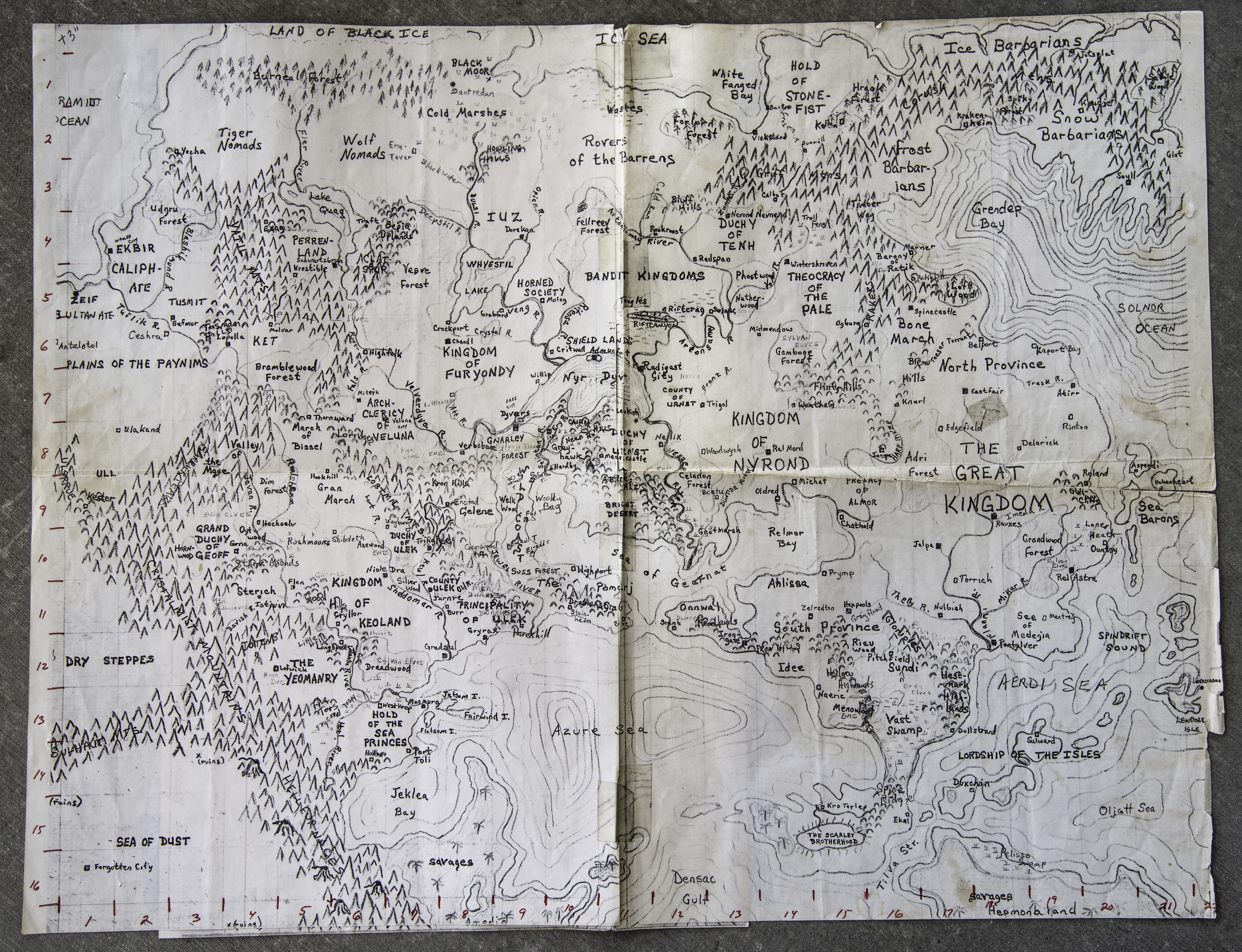
Here is a scan of the old Greyhawk map that was in the trove of D&D material the Len left behind. It is a copy, most likely made back in very late 1970's, of the made that was made to prepare for the upcoming publication of the Greyhawk setting. Len who was a friend of Gary Gygax, but didn't work at TSR, was probably given one to be able to provide feedback, and kept it in his D&D notes.
You can download a high resolution image of it here (23MB; 6531x5009px): https://annabmeyer.com/Downloads/lakofka/Greyhawk%20Map%20Old.jpg
I'll run my Gary Con seminar again on Twitch tomorrow at 4pm PDT (7pm EDT) on my channel: https://www.twitch.tv/anna_b_meyer
The slides and supporting graphics will be available on my patreon blog https://www.patreon.com/annabmeyer before the show starts.
Welcome to a deep dive into Fantasy Cartography, Worldbuilding, Greyhawk with lots of maps!
If you want to download all the slides as a single zip you can get it here (123MB): https://annabmeyer.com/Downloads/other/GC2024Slides.zip
Download manager might be needed.
Got back from Founders & Lagends and Gary Con. 12 days of travel and convention was a blast and so much fun which lasted until the evening I got home. Then I fumbled my con save and got a severe case of something best described as the fly from the nether planes.
After almost a week I'm starting to feel better again. I had intended to take a few days off to do nothing, but this was maybe a bit too much!
I will be on twitch tomorrow, first Gabbin on LordGosumba at 7pm EDT, and the DarlingCreepshow's Gary Con Aftershow at 9PM EDT.
Next Tuesday April 2nd I will have a seminar on my Twitch at 7PM EDT (4PM PDT). I will go over all the stuff I talked bout at Gary Con and anything else that comes up. so please join and ask questions. Slides and more information will be posted, before the seminar.
Do you want to lead your players astray, stall for time or just make them frustrated. Create a map that is wrong, in a weird language, or it needs to be decrypted, needing special magic, maybe it can only be read in the glow of a other planar moon.
There are lots of interesting map options for a creative DM!


