Here is the link to the Final Crater maps.
https://www.dropbox.com/sh/9s5q35t695ckkgv/AADAqoeqCrea-qjqfics_pO_a?dl=0
Only top down maps there right now, more will be added later today and in then next few days. The top down map is available in three different resolutions from 4000 pixels to 16000 pixels, and in the two most popular texture variations.
I've also corrected the shadows, thank you gain Thorfinn for alerting me!

The inaugural project is done, here is a first look at it!
All these images and more will be available to all Patreons in full resolution before the end of the week. Higher Level Patreons will receive additional material as well.
Next week there I will post my my evaluation of the first project, and what I need to improve for the future. I will also announce so additional projects as well.
Thank you all for your support!
The final phase of creating maps and images out if the terrain created.
Time to create the final texture and the top down view.
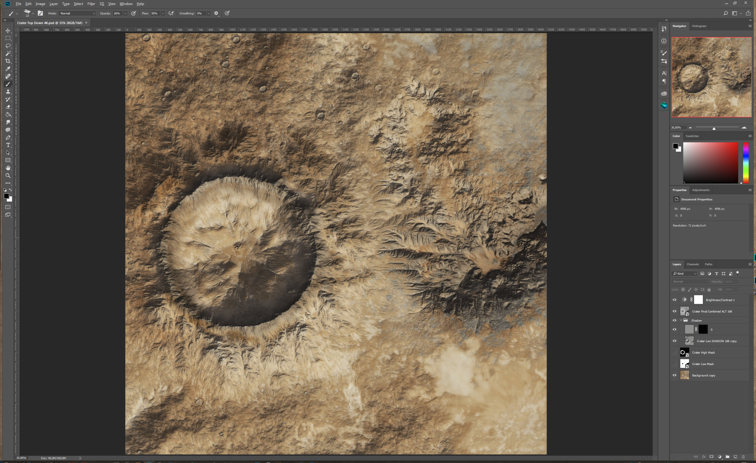
You can get the Photoshop file here: https://www.dropbox.com/s/2n8frcbjiuq079v/Crater%20Top%20Down%204K.psd?dl=0
This is a reduces resolution (4096 pixels) file, the final map are 16 000 pixels, but due to size I have to share a smaller file. Everything works the same and if you want the full size images use the WM files to render them at 8K or 16K resolution.
Lets have a closer look at the layer structure

Good luck with creating your own version of the textures!
A sneak peak at what the final map will look like. There are some neat details to be found if you look really carefully....
A break down on how this is done will come to the Cartographer Patreons very soon, I just need to add few more features 🙂
Working on the last touches of my first Patreon Project, and realizes that this is a learning experience for me as much as for you. Both how Patreon works and all your expectations and also from a technical perspective.
To document and try and explain what and how you're doing things, forces you to think again several times for each step. This have made me realize that I can improve, which I want to do as much as possible.
To match the technical with an implementation in the form of a Creative Commons part (read Greyhawk) is vital I think, both for me to focus my creativity better, and for most of you to get more out of this.
The other part is to evolve technically, which is happening much faster with the more bite sized projects here, more than in the often year long undertakings for my commissioned work. I've already listed a number of things to change for the next project, that I will elaborate on in detail when the Crater Project is done.
There will be a first poll in a couple of days, where you can decide the final looks of the Crater.
Thanks again for your interest, much appreciated!
Time for the last World Machine post for this project, bringing the horizontal slices together again after detailing and using the final texture.

Fairly straight forward with a File Input Device for each of the three ALT slices and one for the combined texture.
The final texture is combination of the three separate textures into one is done in Photoshop (or some form of image editor). My next post (or posts) will go into detail about that process and texture editing.
To seamlessly combine the ALT slices I'm using Combiners set to Max, and using a Blur Filter to soften the edges a bit.
Just like before remember to set the extents to 50 km and the Terrain altitudes to 0 - 10,000 m to avoid distortions. Then you can render the full terrain at your desired resolution, but remember what your input resolution is. No need to render the final combined terrain in a higher resolution than the data of the parts.
You can download my WM file here: https://www.dropbox.com/s/qiawv2n3rnm1rmv/Crater%20Final%2010K-2.tmd?dl=0
Next post: Texture editing, will come soon!

Project Crater is halfway finished. The terrain is created, textured and rendered. The terrain is a 50 x 50 km (30 x 30 miles) bit of very harsh terrain that can either be a planet devoid of life, a very harsh desert or similar location. Final scale will be 10 per pixel.

What remains is Photoshop touch up, final views and labeling.

The plan is to have this project done by the end of the month.


 Unlock with Patreon