I'll be hosting a mapping session on YouTube tonight Friday Dec 3rd @6PM PST.
https://www.youtube.com/c/AnnaMeyer
I will do some more work on the Dragonhide Caves, maybe some more heraldry or SPLAT maps.

Here comes the first look at the updated and expanded terrain. It is important to state that this is still a work in progress with the final touch up to do, but all the features are now present in some form so lets go over the details.
The greened out areas in the SW will be other be covered by legend, credits or cut dependent of format and version and this still not decided.

In the Icy Sea the islands from my Oerth planetary model have been added and even a tiny bit of the Borian (my name) coast. Ocean depths have also been adjusted to match the global continent map, with a much shallower sea in the west and the east and a deep basing in the center of the Icy Sea.
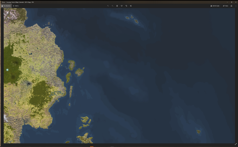
In the Solnor Ocean two new groups of islands are added, both far out from the Flanaess cost. East of the Grendep Bay are the Boval Islands, group of three wet, cold and rocky specks of land. Good fishing and wailing grounds but a bit of a hassle to get to. They can be inhabited or wild and pristine as needed. In my campaign they used to be the refuge for the Suel ancestors of the Thillonrian Peninsula that served as their lands during the last ice age round 6000 - 2000BCY. At the time whey where a much bigger single island large enough to house a population in the tens of thousands. Its was tundra and boreal forest back then. The islands today are made up of the former highlands and has a wetter and slightly warmer climate.
South east of them are a group of islands that have a somewhat similar story but with different people populating it. During the time of ice the Estold's were a much bigger group of islands much closer to the then expanded Flanaess coast with several other now submerged islands and peninsulas. This was the lands of the Ur-Flan and they even ventured out and settled what they called the Rifka Islands. When the Oerth warned up and the Flan retreated, some where left behind or decided to stay, and the Rifkas became a home of two of the last Ur-flan cults. Many centuries later and group of adventures Aerdy explored the Solnor and found the now much more isolated and smaller islands that they called the Estold islands. The confrontation and outcome of this is something I want to detail in an upcoming series of blog posts.
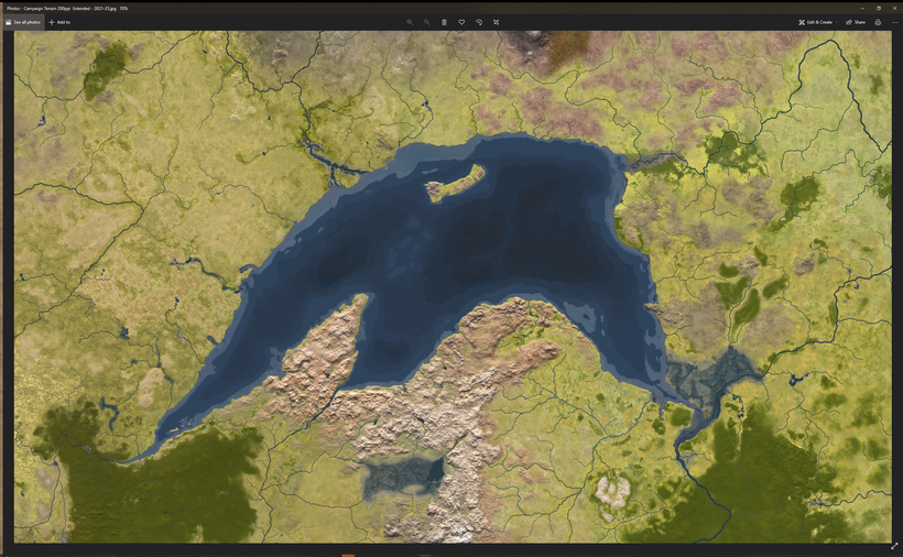
The Nyr Dyv have been given a depth make over including added Isles of Woe hidden under the surface . the first bit of my detailed South Shield Lands map have made it onto the terrain map as well, but in much less detail.

The Nesser River has been upgraded to reflect its status as the biggest river in the Flanaess when it comes to water flow.

The Rushmoors will get a proper water flow, splitting up the Javan into the Kla'arkash River that merges with the Lort to form the mighty Sheldomar.

In the Dramidj the Janasib islands are now included in the small westward expansion. I felt it was important to give the map a more natural western edge along the Gulf of Ghayar. The dried out river from Lake Udrukankar westward is now included, giving the land some badly needed defining features.

Two locations in the Oljatt are added, the Jungle of Lost ships and Turukambi.

The whole of Hepmonaland are added, and I will return with more details on it soon.

The Pirate Isles are given a big upgrade making them conform better to the mini map from the glossography

Ilse of Dread is finally added, it took a long time but now an initial version of the iconic location is added.

A bit of the lands south west of the Sea of Dust are added. These are tropical monsoon and rainforest areas, that still need more rivers and lakes that will be added in the final round of editing.
Played around with the barbarian shields a bit more to try and get them as good as the others. Tried to make them painted in the colors, and then due to wear and tear having the paint flaking off.
I think these looks much better, and have the rugged worn feel you would expect of the barbarians of the north.
What do you guys think?
This one is bold. Here are a test to see how the heraldry of the Barbarians of Thillonrian would look on Viking style shields. I love the Frost Barbarians but I'm not equally fond of the Snow and Ice variants what do you guys think?
Since I'm working on Hemonaland I wanted to make sure I started to look into the heraldry of the area as well, and I really like the look of these. Big thanks to Jay "LordGosumba" Scott for helping me out acquiring a set of template shields for this project, there are more cool things to come from this.
I'll be working on YouTube tonight @6pm PST: https://www.youtube.com/c/AnnaMeyer
I'll try and make some caves, it is a first for me so don't expect too much!
Hepmonaland is coming and here is a first look at my version of it, focusing on the lakes and rivers. The best published map of the continent we have are from TSR11374 - The Scarlet Brotherhood, a sourcebook I really appreciate but the map leaves a lot to be desired. Remember that this is a work in progress and my map is not finished yet!

My main problems with this map are not the styling, it is a good looking map, it is the geography that puzzles me. The rivers are sometimes missing and at other times they slip into two on their way to the ocean. Lets start when the Flanaess map ends at Tchlapac Lake. It has two rivers flowing into it but no run-off which is unusual in most places, but highly unlikely in a tropical rainforest climate. If the lake had been closer to the ocean I would have assumed that it was connected to it through tunnels, in this case I added a river flowing north west into the Pear Sea. This decision I made when mapping the northern Hepmonaland around 15 years ago, just filling in the rest and realized that it needs a bit of widening.

I've made highlands "blend in" with the surrounding lands much more using foothills and gradual tapering of the landscape and also working with different general elevation differences in the landscape. The TSR map lacks the dimension and depicts a flat looking landscape with some hills and mountains protruding here and there. In reality landscapes are much more undulating and gradually shifting with high plateaus, mesas and plains that are sloped in various direction. All of this without really qualify as hills or mountains.

The Ikani and Ibaz rivers have been given lots of tributaries and neighbouring smaller river systems. Jungles also don't stop growing 76 miles from the coast. I know it must be tempting for a traditional illustrator or artist to accentuate the coast like this to make them look pretty, but in my project we are out for a bit more accuracy, so the equator jungles extend to the coast for the most part. Especially on the eastern coast of Hepmonaland due to the more humid climate further south.

The Iyapo area wit its Adaro forest presented a challange. I see the southern, and especially the south western Hepmonaland as dry and hot desert with band of savannah south of the jungles near the equator. To try and fit a huge forest in the desert presented me with an interesting challenge to try and bring water to sustain a forest to this dry land. Thankfully the TSR map has no rivers at all in the SW Hepmonaland, so lets assume the western coast is of the more high and cliffy kind redirecting the flow from the western Kelo Hills mainly south. The rivers drain into a large shallow depression on a plateau creating a huge wetland that will be mainly overgrown with forest. Due to the tropical and humid climate in the region where some of the rivers feeding the Adaro it will receive at least some water all year round. A small runoff meanders down the mesa to the north west, filling up only only occasionally when the rains are extra abundant in the Kelo Hills.

The TSR map has another conundrum, Lake Keli. The Keli lacks a runoff, which I added flowing to the SW into the ocean near Byanbo. Just like the Adaro, Lake Keli in the hot climate probably evaporates way more than it dilutes into the ocean. So the river valley I have added will mainly be dry. Water evaporation creates a regional climate wet enough to enable the Tabo forest to grow and create very favorable conditions for agriculture around the lake.
Byanbo and the Ino Hills are said to have volcanoes in them so I made them a bit more impressive since Hepmonaland highlands are not described as either tall, great or in any other way significant. I'm taking this as a sign of interest on the writers and not a lack of geographical significance.

Here is a typical example that from a geographical view, the name being the most interesting bit of information. The TSR map is just a blank and what I've done so far is only the start, this island requires some more work to try and create a landscape with black rock pillars that can sing!
Time to give a first work in progress sneak peak of the biggest map update since I started mapping the world of Greyhawk over twenty years ago: Hepmonaland!
Yes the southern neighbor of the Flanaess will come this holiday season expanding my mapped area almost 50 percent. It will be the same style and resolution as the existing map, and hopefully even better quality.
It a straight to Photoshop terrain map and I'm very happy with the results so far, at least as good as the existing map with lots of character to the landscape. Tutorials on how to create maps like this will come next year as well as textural and shading recourses to Cartographer patreon members.
This is not real 3D so only top down views, but it will provide a useful and beautiful reference map for future use. The green rivers are just a signaling color I use to see what I'm using during map creation. Terrain work is around 80% done and I hope to have the terrain done in a week or so.
This is a project I have been able to work full time on in secret for over a month now thanks to your support. With more support I can spend more time on this and I want your investment to be rewarded.
I'm working on getting the detailed terrain features right, river valley in the right places, a few volcanoes and hidden valleys etc. Left to do is to go over the coastlines and water textures and the final overall tweak of saturation, sharpness and grain.
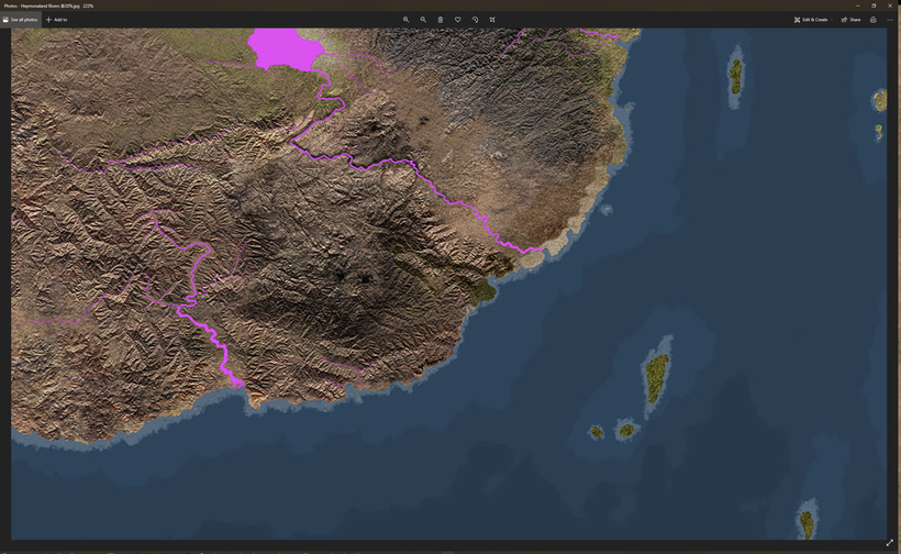
An overhaul of the rivers of all the rivers of the Flanaess are also done. The Franz, Horned Society, Furyondy have received special attention with added small rivers to complete the drainage. The Nesser have been adjusted to better promote its role as the biggest waterway in the Flanaess.
Lots of small rivers got lost when I reduced the resolution from 600ppi to the now used 200ppi, and now those lost small rivers are restored again.
Water depths will be looked at across the whole map and islands will be added in the north, west, east and south to match my Oerth planetary model. Most of the islands are outside the area of the Flanaess map but will be added to the expanded Atlas.
A more complete look at the terrain updates will come soon for all patreons, this is a short little sneak peak for you guys.
Thank you again for making this possible 🙂
Work on the Map and Atlas 2021 updates are under way, and here is a work in progress screen shot of the Isle of Dread. I'll keep working on the terrain for another couple of weeks and hope to be able to get some more area covered. Ocean depths are almost done and terrain is progressing well, and I have a ton of settlement and symbol updates ready for November and December.
I'm so glad you like the my new take on heraldry, I think they are really cool and heraldry have become more and more a passion of mine and a topic that needs more attention. I made new versions without the edge and rivets which I think looks better, what do you guys think?
My Shield lands stuff will be simmering in the background until next year, but a few cool things will be coming in that area as well. More locations and heraldry at least, but main focus is on the updated main map and atlas.
When it comes to heraldry I'm thinking it might be better to skip the heraldry appendix this time and concentrate on the map and index parts of the Atlas. Might be better to save the effort for a dedicated Greyhawk heraldry compendium next year, what do you think?


 Unlock with Patreon