Tonight! Friday Night! Join Allyssa Faden, Jay and me for the Fantasy Mapping Show - Ep. 5: Settlements!
Come with your questions ready! Fri, 10/15, 8:00 PM EDT

Improved heraldry have been on my To Do list in like forever, to try and create versions of the heraldry as they would look in the world. Now I'm having the graphics mojo to pull that off so I decided to have a go, and here are the first results, Greyhawk and Tehn.
The old heraldry are probably better in the small size needed on maps, but for illustrative purposes and immersion I think these are cool. What do you think?
Here are my Shield Lands Campaign slides from my Virtual Greyhawk Con presentation. It nearly finished set of point of interest maps for the Southern Shield Lands.
The buildings have no height yet but apart from that they are almost all in a finished state. I'll be back with finished versions with more backstory and heraldry in a couple of weeks.
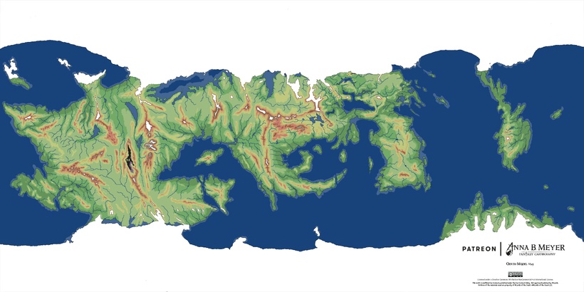
When I started my Oerth planet model project it was to try and place the Flanaess position on the globe for my transition to use GIS. Then the more I got into mapping Oerth the more interested I got and starting to see possibilities and overlooked connections with the familiar stories of our favorite game setting. The geographic dimension of most fantasy setting seems to be rudimentary at best and Greyhawk follows that tradition of taking geography lightly and as a "mood setting backdrop" rather than a key aspect in shaping the stories. Science is telling us that the planet and its geographic aspects plays a central part in shaping all life, I think that should be the same for fantasy worlds as well and this project have given me a good opportunity to do some "Oerthly fantasy science"!

I've modeled the planet as I see it during the time of the Greyhawk campaign in the late 500's CY, as well as an version of Oerth in an ice age as well as during a hot climate. When and if you want to make use of ice ages and warmer periods in your campaign history will vary, but if you do there are some very interesting possibilities present themselves.
Almost all fantasy setting comes with mysterious ancient cultures present in relics, sites in remote places and monuments hidden away in now inhospitable realms. Why these civilisations choose to build in the far off hostile regions the stories rarely tells, and here I think a geo-historic approach can be very helpful in both inspiring and explaining stories like who built the cairns in the Cairn Hills for example. So lets take a deeper look at what Oerthly geography has to offer!

Civilizations need favorable and stable conditions to persists over long time to develop and thrive. In the map above I have marked out areas that are the most favorable over time for human like habitation, having a non arctic and non desert climate, and that are not prone to flooding in times of higher ocean levels. Interestingly the southern Flanaess, northern Hepmonaland and parts of the Amedio are well represented. This makes this region a prime candidate for the earliest civilizations, so maybe there are something into the idea of a human origin here evolving into Olman, Touv and Flan cultures.
With the data of were the best long term areas for a human like civilization are, lets plot out good locations for city building in these areas. Access to waterways are a key fact in this, and below is a map where I have done this for Oerth.

A number of familiar locations show up, like Greyhawk, Chathold, Prymp, Rel Deven, Irongate, Pontylver and Lo Reltarma. It might not be a coincidence that the eleven cities of Enstad, Courwood and Tringlee all are in this very stable and favorable location, the long lived elves could very well have used heir historic knowledge. Today there are many other places in the Flanaess that are better locations for a major settlement, the strength of these locations are that they remain usable even in the case of a drastically changed climate. Lets look into how a hotter and colder climate will affect settlement patterns across Oerth beginning back in early human history and try look at Greyhawk history from a geographical perspective.

Cold periods in history gives primitive humans and other civilizations new opportunities to expand across the planet in areas otherwise inaccessible, ocean levels are much lower creating land bridges, and the deserts are both smaller and less hot. Early hominids can begin spreading west and diversifying, this early ice ages is the first time of migrations, land migrations due to both lack of technology and large parts of the ocean are frozen over.
Then the Oerth climate begun to heat up...

A new world emerged where the oceans opened up and the land was often turned into scorching hot deserts. The western humans turned to the sea and migrated away from the heat towards the newly opened up north. A seafaring culture was created around what is now the western Dramidj, and back then is was connected to the tropics across oceans that have previously been deserts and steppes. This is the beginning of the Suel, the first great sea farers of Oerth. The Ur Flan where happy ruling the best lands on the planet with scant interest in exploring other parts of the world.
The Olman world was thrown into the sea, literary, and large parts of what was left was turned into desert. This delt such a blow to Olman development that they haven't really recovered from it since. The Olmans of the southern Hepmonaland was isolated giving rise to a new off-shot culture, the Touv. The Touv used favorable winds and ocean currents to reach both the great southern continent and Mentzeri in the middle of the Solnor.
The people that lived along the northern coasts of what would become the Baklunish lands enjoyed a favorable climate but the expanding gulf of Ghayar separated them turning them into the precursors of todays Baklunish and Oerids, the Bakluni ancestors on the wester side and the Oerids on the eastern.
Life like this went on for a long time but big changes where coming, winter was coming. Oerth was dragged into a new ice age with a cooling climate. This meant problems for some and new opportunities for others. the first to be hit by the oncoming cold was the Suel in the far north. They were forced to relocate south and came into conflict with the Balkuni, and to a lesser extent the Oerid that held lands further east. This meant hard fought battles for survival and the Suel was the less experienced in land warfare and was often driven to flee. The Suel fled in two directions, one smaller group of eastern Suel settlers along the Corian polar coast decided to try their luck and fled eastwards to the Thillonrian Peninsula and ended up occupying a group of larger islands in the northern Solnor east of mainland Flanaess that where exposed due to the sinking ocean levels. This group would later colonize the Thillonrian when the climate warmed up again.
The main part of the surviving Suel ended up on a plateau south of the Suel that was turning from being a desert into fertile lands with a set of large lakes and decided to stay. They would form the pinnacle of Suel civilization over the next 5000 years, but their memories of the wars with the Baklunish would remain in their tales...
The Oerids and the Baklunish divided up the tundra, steppes and huge forest of the Baklunish basin. The Oerids had their back towards the glacier covered Yatil, Crystalmist and Sulhaut ranges develop a fierce stance towards intruders so the Bakluni opted to spread west and south instead.
In the Flanaess the Flan now came into their cultural zenith developing large settlements and a multitude of large and powerful realms whos names have survived all the way into modern times. Conflict broke out with the demi humans and the Olmans in the south and a darker warlike side took hold.
Then winter began to ease its grip and the Flanaess we recognize is starting to emerge. The Balkuni had picked up strength and numbers in the west and south, and when the lands they where living in again turned to deserts, they moved north to reclaim their ancestral homelands. The Oerids were surprised by the renewed vigor of the Bakluni, and also tempted by the very promising opportunities in the east and north that the warming climate created. Instead of defending the lands turning into desert they stated migrating in ever larger numbers north and east through the newly opened Thornward gap.
The Suel saw their arch enemy move in north of the Sulhauts, their plateau was fast turning into the desert it used to be and plans for a revenge started circulating, and the rest we know..
This is far from complete story, I have left out the humanoids and several other actors. It shows an interesting way you can use geography and climate to inspire, support and help out in creating a more interesting and deep fantasy world.
Let's take a closer look at the Flanaess and how we can use this.
Below is the Flanaess in cold times with good sports for settlements in the cold and persistent times.

Then a look at hot Flanaess

and then combine all of the info on the current map and we get some interesting results...

Now we can see likely ancients site and the period they hail from. I can see interesting backstory possibilities for the lair of Dramidj, the Egg of Coot, ruins in the Barrens, the Land of Black ice and the coast of the Tiger Barbarians where Myrlund resides. I'm sure there are more interesting connections to get from this, time to get creative!
This is going to be one of the topics for my seminar on Virtual Greyhawk Con on Friday.
Thank you again for making this possible!! 🙂
I'll have a go at my Flanaess terrain map again, this time it will focus on updating the rivers.
I will start 6pm PDT and you can tune in at: https://www.youtube.com/c/AnnaMeyer
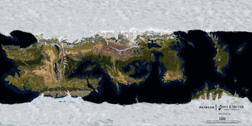
Previously we looked at the "normal" Oerth and then a Cold Oerth gripped by an ice age, now its time to look at the opposite Oerth scorched by a scorched climate a bit more than ten degrees above normal. This model is a bit more speculative than the normal or cold, science on ice ages are a bit more developed, but due to our real world changing climate knowledge of a hotter climate is increasing fast. So lets take a look at our World of Greyhawk in a more fiery age.

Large parts of Oerth are in this scenario uninhabitable by all except the hardiest of heat loving creatures. Four large and a number of smaller areas are turned into extremely hot deserts that will quickly kill most creatures that lack protection from the heat and sun. The biggest of these desert are as usual in the Western Oerik and it has made the interior of Oerik a hot hell home to elemental creatures, Red Dragons and others who not only survive but thrive in this inferno.

The situation is not all bad, the increased global temperature have melted almost all the glacial ice, that Oerth has a lot of even in normal times, and way more of it are on land rather than on water. So when all that ice melts it will raise the sea level by hundreds of turning most of low lying land into shallow ocean. This means that some areas that used to be desert now enjoy a much more pleasant coastal climate even in the hot tropics. Oerik is broken up into a western and an eastern part with a number of large island in between opening up for seafarers in a way that makes global shipping possible almost everywhere from the poles to the tropics.

Flanaess
Our beloved part of the world hold out well in this scenario, large parts of the central parts are now a shallow ocean and the Cairn Hills are an island in it. The Howling Hills are close to the coast covered in lush forests just like the rest of the lands from the Dramidj Coast in the west all the way to the northern Thillonrian who now sits firmly in the temperate belt. The northern Great Kingdom all the way up to Ratik is now Mediterranean and the southern part not under water range from savannah to tropical on the coast of Sunndi. The Wast Swamp are now a flat dusty salt plain in a small but hot desert formed in the Sunndi depression.
Western Sheldomar Valle are now a dry hot et of hills overlooking a large ocean inlet stretching all the way up to the borders of Bissel. The Crystalmist Mountains are high enough to stretch into the sub arctic and are now home to a large evergreen forests. The Baklunish lands range from very pleasant in the north to a scorching hot desert in the Dry Steppes making normal life south of Kester almost impossible.
The Amedio sit right on the hottest latitudes and except for the cooler coastal lands is now a desert. Jump over the Hellfurnaces and the Sea of Dust is even hotter desert, probably one of the hottest on Oerth. The Suel will have a tough time in this scenario, but so will the southern Bakluni as well as large part of Hepmonalanders. Mostly desert is what the hardy Olmans and Touvs have to face, but thanks to its coastlines there are still savannahs and even rainforests along both the west and east coasts.
Fireland
This is a scenario that should please most Firelanders turning it into something like a volcanic and more mountainous Ireland. Getting here from the mainland should be easier as well since you can use the north polar coast that are now home to the largest Boreal forests of the planet. The relatively flat north polar area is almost devoid of glacial ice and now accessible for most of the year opening up northern areas for settlement and travel. Huge tracts of lands north of Western Oerik can now be home to whole civilizations, since it rivals the Flanaess in size and now has a cold but temperate climate.
The great southern continent have shrunk a bit due to the higher sea level but sports some of the most inviting climates on the planet. A tropical ocean between the two halves of Oerik has taken shape with a myriad of tropical islands along its many thousands of miles. One can imagine a ruined city on a hill in the middle of the desert that was not too long a go a coastal metropolis catering to the trade north and south between Western and Eastern Oerik when it was a warm sea full of life. On our normal Oerth it is just a wast hot mainly flat desert, but with a bit of geographical history you can get inspirations to very interesting stories.
Take some time to study the differences between this scenarios, see if they could fit into your campaigns timeline somewhere in the past, or future, and I hope they can inspire you to come up with interesting things to add to your games.
The next installment in this series will be a look at where the most stable conditions on Oerth are to be found, so if you want to set up a civilization where are the best spots.
Thank you again for your support!!
Worked a lot more on my Notion Greyhawk Repository and it is hopefully starting to become useful. I've uploaded a lot of stuff, both old and new. There are search functions and pages dedicated to various projects.
Notion is a great tool to use in my end, I hope that that the usability carries over for all the users as well. Time and usage will tell, so please give it a spin and tell me how it goes.
I've created a Bitly short link to it:
This one turned out to take much longer than I thought, I got caught up in its intricacies realizing its historic potentials.
My premise for this version of Oerth is a version of Oerth not too long ago, geologically that is. How long ago is up to you in your campaign, but recent enough for the continents are still in the same place, so thousands rather than millions of years. The assumption is that the climate is around ten degrees Fahrenheit colder than what we are used to, similar the conditions on Earth at the Last Glacial Maximum circa 20,000 years ago. Add Oerths axial tilt, larger landmass and it gives some very interesting results. Been helped by friends who are experts at this in the real world and they gave me some great inputs that I let guide me on the journey to see what a cold Oerth might look like.
The Flanaess
Northern Flanaess are covered in a thick ice sheet, often a mile thick, along its entirety. Only the many mountains of the northern Flanaess, from the Ytails in the west to the Griff and Corusks in the north east towers over the ice. Central Flanaess are now a artic frontier with a band of tundra before the thick ice cover towers just north of the Rift Canyon. Whyestil Lake is permanently frozen over and the peaks of the Howling Hills are barely visible through the ice. A band of Boreal forest stretch from Bissel to what will become the northern Great Kingdom, with an arm following the Lortmils all they way to the Pomarj. Nyr Dyv is larger due to an influx of meltwater, turning large parts of surrounding lands into wetlands in the warmer months.
Western Flanaess are even colder, the smaller Dramidj Ocean suffered from not having an influx of warmer waters from the tropics and mountains in the south kept out what little wamer air was still around in those cold times. This have turned the Baklunish lands into an arctic borderland. The Bramblewood gap are now frozen over all year around along with most of Ket, isolating the Baklunish lands from the Flanaess. Most of the The gulf of Ghayar freez in winter and the Dramidj are frozen all summer making the sea inaccessible, but its waters are high in spring and summer due to ice melting flooding large areas seasonally.
Eastern Flanaess fairs much better thanks to the large Solnor and the warm currents from the south. It is also much larger due to the fall of ocean levels, large parts of the shallow waters are now some of the best real estate on the planet with an temperate oceanic climate and covered in deep forests. I can see this as perfect hunting grounds for the early Flan, roaming across what would become the Aerdy lands to Lendore Isles, now a range of hills part of the mainland Flanaess.
Sothern Flanaess have experiencing some of the largest changes with lots of additional lands. Olman lands are now much more of a coherent realm stretching from Hepmonaland in the east across a land bridge connecting Tilvanot with the Amedio making the Azure into an inland sea. The Amedio is much larger with savannah and jungles across what used to be shallow waters. The former wester Azure are now very habitable lands with oceanic and Mediterranean climates, with to small inland seas with brackish waters that used to be the Jeklea Bay and the deep waters south of Gradsul.
Hepmonaland
It is now a part of Oerik with a land bridge across what used to be the Tilva Straight. It has expanded a bit covering the once shallow costal waters and a new set of islands further out have risen out of the submerged ocean. The hot and dry south are still home to hot steppes and a small hot desert but the southern coast are now sports a cozy med climate, perfect for characters who need a nice warm place to retire.
Central Oerik
The western Dramidj are now an inlands sea with a northern icy coast and the biggest stretch of boreal forest on Oerth. The interior is is till dry but much colder, turning the hot desert into cold dry steppes and deserts with band of hot ones in nearer the tropical south. South Central Oerik is the least affected by the cold climate, still wet and warm full of forests and savannah.
Western Oerik
These huge lands have grown even larger as the oceans sank, but a large part of the south are now a frozen world. This is still home to a large hot desert, smaller but still the biggest on the planet by far. The northern and southern parts of this huge chunk of dry lands are now tuned into cold deserts and steppes, much like inner Asia on Earth. West of this is now the biggest lands perfect for settling with empire sized realms ranging from tropic to temperate climates, covered with huge forests from jungle to boreal.
The Great Southern Continent
Is mostly covered in ice except for a few hundred miles wide stretch of northern coast of temperate and even Mediterranean climate.
Fireland and Mentzeri
I hope Carlos can forgive me for covering his beloved island under thick ice. To compensate and make it more interesting I've connected it to the mid Solnor continent, I call it Mentzeri as an homage to Frank Mentzers Antaria, using a now visible mid ocean ridge. This will connect Fireland and Mentzery to the rest of the land for frost loving creatures opening them both up for more interesting adventuring possibilities.
There are other interesting tidbits in this project, but I'm going to let you guys find them yourself before I point them out...
Whether you want to use this as an distant historical background or a fast approaching future, I hope it can provide a useful new perspective on the home planet of Greyhawk. Next up in this series will be Hot Oerth..
Its been quite a while since I did an update going over the various project and their status, which is extra important when there are little finished content delivered.
I'm working on several fronts at the same time which might not seem to be the smartest, but there are some good reasons. A major one is ergonomic, after a day or two of Photoshop editing my hands and arms can feel the train of using a Wacom pen for hours, so I need to switch focus to the muscles and tendons time to relax and recover. Working in World Machine, especially with development is a good antidote, its mainly brain work trying to figure out and test what works and gives the best results. The other main reasons are that I need to keep both you guys and the publishers giving me commission work to do, and I need to alternate to stay creative and interested in what I do and avoid being burned out.
My biggest project at the moment are the map for Griffons Lore Games Trials of Arcadia, a detailed area map to be used for the hex crawl campaign. We are in the late intensive phase with about a month to go before deadline, and my goal is to have it done a bit earlier than that. It is an technically interesting project that uses the same setup and workflow as my current Shield Lands project, but at lower resolution to cover more area. You can find out more about it here: https://www.kickstarter.com/projects/fireonclaymorewoods/trials-of-arcadia-for-5e-and-pathfinder-1e-a-miniature/
Southern Shield Lands @5ft/pixel
It is progressing well, with the first area almost all done. I plan to do a mapping live stream Friday this week to do the last bit, building heights and some touch up before the final renders. The results are masses of terrain to get lost in, and the vistas look as good as I had envisioned at the start. The final renders will hopefully be done next week so we can have look at things in detail.

One little caveat is that the western edge will be changes when I merge it with the next area since I have tweaked the river and its valley eastern edge is on the area almost finished. This insight have made me realized that all areas of a project need to be developed in parallel as much as possible to avoid having to redo parts of an area. It is insights like this and how to either prevent the problem, or how to best fix it afterwards, that I do test projects set in Greyhawk to work out the kinks. It is a lot of testing and some dead ends but in the end the goal is to figure out a better way of doing better maps.

The major problem with the "bottom up" approach in this project is that the maximum resolution I can work with is 16K which means 15 miles at 5 ft/pixel. World Machine creates each render area essentially as a separate world which means that rivers and even elevation doesn't match perfectly when you merges the area tiles afterwards. This can be fixed for the most parts, but rivers are special problem since they need to flow downhill and over many areas which means I have to manually create them rather than using WM's built in river tools. WM's tool generated rivers also have a problem with lack of meander and other natural features, which means they have to be created artistically sung splat maps in in Photoshop. This gives excellent results but is very tedious.

The way around the resolution limit is to render using tiles, which is not functioning properly in WM3. In the latest version of World Machine tiles works much better so hopefully this means it would be possible to render up to 64K covering a square 3,600 square miles instead of 225. Tests of this will begin in a couple of weeks, and I'm optimistic, it might be a breakthrough needed to get up to speed.
Oerth Modeling
Thank you for all the encouraging feedback I've received for the Oerth model, next step is to look at cold and hot versions of the planet. I want to spend a bit of time doing this to get a better sens of historic possibilities and how that can have shaped history and evolution of things on Oerth.

Cold Oerth with so much water bound in ice will have all the major oceans lowered, turning much of the continental shelves into land. Just like on ice age Earth this connects landmasses normally separated by oceans. On Oerth it is Hepmonaland that are joins up with an expanded Flanaess and an even greater Oerik. Ice and new land bridges connects all the major continents which opens up for interesting possibilities that cold living creatures (and their siblings) can be found on all the continents, depending on how you implement ice ages in your campaigns. This is sill a work in progress so with some tweaks still needed, but the major features are there. It is a great learning opportunity for me , receiving help from friends wo are experts in climate and oceans trying to figure out how the fictional Oerth could experience Ice Ages and hot spells.

Hopefully you can find this interesting as well, as a way to spice up the ancient (or recent) history, or as a future seek or avoided. Divine powers might screw with the climate as well as natural phenomena, there are lots of options!
Content Repository
My test using Notion to store and access my content turned out to work rather well. So I'm going to ramp up my effort and upload more of my stuff, index it and link it up with my website.

Flanaess 2021
The big Greyhawk project of the year will be the 2021 Map and Atlas update, with the goal of bringing both the 576CY and the 598CY maps up to the same standard. The terrain will be edited to fit with the Oerth planetary model, which is mainly ice cover and islands in the icy sea and ocean depths. An expansion south covering the Isle of Dread and more is also planned for the 2021 Atlas.
The Atlases will be 11x17 single page maps, which will mean a larger number of maps but no overlapping fold to deal with. This means I can export each map in it its final version from Illustrator keeping its layers and vector format for the PDF versions which means better prints and the ability to hide layers not needed. The overall number of pages should be roughly the same, around a 100 or so.
This is hopefully the last Illustrator based version of my old Flanaess map, it is my goal to start develop GIS versions next year. This will create the base for proper printed and online map version and more going forward. This is huge undertaking but worth it in the long run, opening up a world of new possibilities.
Hand Drawn Flanaess

My desire to create a set of hand drawn maps as a compliment to the accurate reference maps got a test run this year, and some of you like the result and they can be useful. I'm going to keep them on my future agenda but treat them as a hobby project to work on when I feel like it and need time off regular projects. I want to keep it in the back burner ready to pursue if a when time might appear for it.
Lendore Isle
Mapping the Lendore Isles is a project that seems cursed with all sorts of interruptions. Planned to have started almost a decade ago, first it was delayed due to Len's cancer, and when he recovered we started working on it for a bit when he relapsed and then sadly passed away last year. The other issue is that I have always wanted to use the best options possible for this, but those options have been a very moving target the last two years. I decided to try out both a "bottom up" and a "top down" approach to see which is best. Shield Lands became the bottom up test and Lendore isles the top down test project, and already early on the bottom up approach was much more productive.
I haven't abandoned the Lendore Isles project, but the top down approach needs re-thinking, and if the bottom up approach can be made more efficient that might be my way forward for most of my Greyhawk mapping.
Unreal

The next big leap after GIS is game engines and will be a parallel technology used for digital visualization. The first test have begun and they are very promising, but limited. The goal for initial testing are to make sure that the data I create using World Machine, Photoshop etc in my creation process can be used in Unreal, and not only work, but work well. It is essential to future proof as much as possible to make sure that what I create now can be used, and improved on, in the future using better tools when they become available.
Thank you!!!
Thank you so much for your support it literary means a lot to me, a major part of my income and occupation and gives me an opportunity to work on pushing the boundaries of fantasy mapping, and keeping Greyhawk the best mapped setting in existence. I know that the competition ramps up but with your help we can keep Greyhawk in the lead!
My presence online have increased significantly with the Legends & Lore show together with Mike Bridges and Jay Scott, The fantasy Mapping Show with Alyssa Fade and Jay Scott, and often being a guest on Jays Sunday Gabbin shows. The latest addition to this is live streamed mapping sessions on my YouTube channel. I choose YouTube due to its support for higher resolution, streaming at 1440p which is a lot easier to work in than 1080p. I underestimated the interest in watching me working Photoshop, so I will keep doing it on a weekly basis trying to show different aspects of my work.
Here is the PSD source file I've used for this project. I'm trying out to attach files to a patreon post for the first time, I hope it works for 180MB files.